
Here we report a series of experiments that further supports the findings of the QEX article, and give details of the measurements of an obstructed path of almost 200 miles using an operating frequency of 10 GHz.
Going back to the 1930's, microwave radio wave propagation has been known to extend beyond the obvious horizon. This has generally been called tropospheric scatter propagation. Over the last several years, a group of amateur radio operators in the Pacific Northwest region of the US have been exploring this mode with particular emphasis in the upper regions (10 to 40 kft), normally considered a minor contributor to the signals used for communications. This has been written up in July/Aug 2003 issue of QEX magazine, B. Larkin, L. Liljequist, and E. Manly,
"Microwave Propagation in the Upper Troposphere," and is available on-line.
This article is assumed as background for this web page.
The event of 9 Sept was recorded by KD7TS as screen shots. Combining three screens gives a long-term view <M909V.GIF from about 0500 to 1230 UT. This view also shows the Doppler shift changing slowly, indicating the angles between the moving scattering media and the signal path. The center (audio) frequency of both the transmitter and receiver is closely held to 600 Hz. The marks at the top of the page are every 125 Hz, so the nearest mark to 600 Hz is at 625 Hz.
Notes on 10 GHz tests, W7PUA to KD7TS 4 Sept to 15 Sept 2003.
de W7PUA
These tests were conducted continuously at a frequency of 10368.032 MHz. W7PUA in Corvallis, Oregon transmitted to KD7TS in Des Moines, Washington. The transmitting end used 4-Watts and a 4 foot (1.2 m) parabolic dish and the receiving end used a 1-m dish. The receiver system temperature was estimated to be 300K. The take-off elevation angle at the transmitting end was limited by local hills to about 4 degrees. The receiving end was able to view quite close to the horizon, with a takeoff angle of a degree or less. Both ends were fully phase-locked to the GPS satellite system and capable of
holding the RF frequencies to a few Hertz. Transceivers at both ends were the DSP-10 and the spectral data recording capability of this device was used extensively.
The path (profile.gif) is about 196 miles (315 km) in length. In the plot, the KD7TS end is on the left. The south end takeoff angle is a significant restriction for this path at any VHF or higher frequency. The common volume is at about 25 K ft (7600 m) and is roughly located over Portland, Oregon.
Mike, KD7TS, has collected a large amount of data over the first half of September. This includes:
DSP-10 Screen saves
DSP-10 Spectral data, mostly at 10 min intervals, in .dat format
NexRad radar images
IR plots from GOES-10 satellite, including "movies"
Misc data, such as path profile.
I have selected small amounts of the data and attempted to extract summaries and to draw a few conclusions from
this data. These notes are to explain the plots.
SIGNAL STRENGTH - Plot m9a3.gif is plot of the peak signal strength over all 11 days. Peak means that the spectrum was examined at each 10 minute interval to find the strongest level. The resolution bandwidth is about 4.7 Hz and the Doppler shifts do to the moving scattering media are much larger. This has two effects. First one must hunt for the center frequency, as this may be 50 Hz or more from the transmitted frequency. Second, the peak signal strength is less than the total return due to the spreading of the spectrum in the random media. During this experiment, the total signal ranged between 4 and 10 dB stronger than the peak values that were plotted. Narrower spectrums produce the lower values.
Aircraft are sources of scattering that are interesting, but not the primary focus of this experiment. These signals were observed to be similar in strength to the higher values of tropospheric scattered signals. Aircraft are easily identified by their rapidly changing Doppler shifts. The aircraft will usually move in and out of the antenna beam in a few minutes, or less, with hundreds of Hz shift per minute. When looking at the 10 minute power averages, the aircraft signature gets blurred. The method used here to find aircraft was to compare adjacent 10 minute intervals. If the signal in all three 10 minute intervals was not fully detectable, defined to be above -175 dBm, it was discarded. The results of that filtering are shown in the figure, m9a3.gif. Probably some valid data points at strengths near -175 dBm have been discarded, but this is not apparent. The isolated aircraft events, on days such as the 12th and 13th are removed, however.
The calendar dates shown on the plots have tick marks at the start of the UT (Greenwich) day. In PST this is 4 PM. The vertical grid lines are at 8 hour intervals for the full 12 day plots.
Many of the days, such as the 11th 12th and 13th did not have measurable signal levels, meaning above about -175 dBm. There were four or five times when the "band opened!" Looking at the GOES10 IR3 Water Vapor maps for those days showed the previously observed low temperatures of -40C or lower. The data and event were well recorded for early on 9 Sept, and that event will be explored in some detail.
SEPT 9 - The detailed plot, m9a1.gif, shows the signal strength breaking -175 dBm about 30 minutes before 9 Sept, UT (the plot grid is 2 hours here). The peak strength remains around -165 for about 4 hours, takes a dip for an hour or so, and then is generally about -160 dBm for 6 hours. At this point the signal drops rapidly right at 1200 UT (9.5 on the plot). Some idea of the related weather can be seen from the NexRad radar maps. RA9090145.gif shows that rain is starting to move into the area, associated with an approaching cold front from the west. The radar map RA9091256 is about 11 hours later and shows the cold front about over Portland, the common volume area.
Another view of this same event is from GOES-10 IR3, that shows the temperature of the highest level of the water vapor. WV9090030.GIF is at 0030, showing the high (cold) water vapor has just passed over Portland. Roughly 4 hours to the west is a break in the green color, corresponding to the signal dropout, and then another area of high water vapor for the returning signal. In this write-up, the term "water vapor" includes condensed material, probably in the form of ice particles. Next, in WV9091300.GIF, the cold water vapor has just passed Portland, corresponding to the time of signal drop from -155 to -180 dBm. The line between cold and warm water vapor is very distinct in the IR3 map, and the drop in signal strength is also quite sudden (about 30 minutes).
SPECTRUM - All of this data lacks the characteristics of rain scatter. the spectral spreading is typically less than 100 Hz and center frequency is within 50 Hz of the transmitter frequency. As before, we speculate that the doppler shift and spread is associated with the jet stream travel of the turbulent clouds of water vapor and ice.
A plot was made for all non aircraft signals at -175 or higher. This excludes most observations that have large aircraft Doppler shifts and those that are extremely noisy. m9a2.gif plots this center frequency, calculated as the center-of-gravity of the power weighted spectrum. Each of the four or five signal events have a different center frequency and within the event, changing patterns can be seen. These probably correspond to the directions of the jet stream during the water vapor passage.
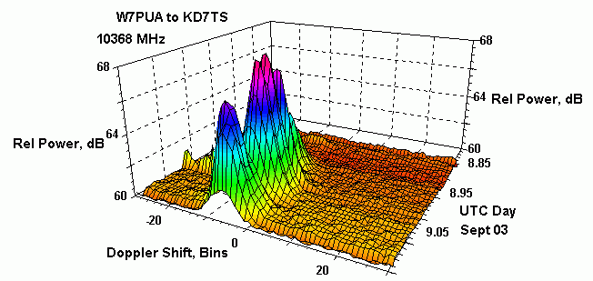
The 3-d plot at the top of this web page illustrates the changing signal strength and Doppler shift. Another view of the data comes from the DSP-10 screen waterfall. An example of this M9071511.GIF, shows in the lower-right portion of the
screen the received signal and its spectrum. This is recorded over about 3 hours. Stronger signals are brighter colors. In four places there are strong almost-horizontal streaks caused by airplane scattering. The fast moving airplanes cause large amounts of Doppler frequency shift. Further information on the DSP-10 radio is available from :
http://www.janbob.com/electron/dsp10/dsp10.htm